

MARKET OVERVIEW
The Asia Pacific land survey equipment market has expanded to become a dominant sector in a broader spectrum: geospatial technology. These involve measuring and mapping devices and equipment for land. The industry is accompanied by precise instruments created to function in construction and engineering, from environmental research to city planning. Recently, the sector has been recording multiple growth; technology plays an enormous role in revolutionizing traditional methods of surveying.
The heart of the Asia Pacific land survey equipment market is a variety of advanced equipment: Total Stations, Theodolites, GNSS Systems, Laser Scanners, and Drones. Total stations integrate electronic distance measurement and angle measurement for providing precise data to attain site analysis and layout effectively. Theodolites, traditionally employed for the same function, are making way for digital ones for improved precision and convenience. The GNSS solutions are robust for geolocation and mapping for huge projects that would be impossible without precise positioning. High-speed data collection and high-resolution image capture became sought after for laser scanners in the Asia Pacific market.
These scanners allow for the production of precise 3D models of survey areas, which in effect enhances the visualization and planning stages of various projects. The second technological wonder is the drones, which have revolutionized the face of land surveying with their special aerial view that was previously hard to achieve. Fitted with high-definition cameras and sophisticated sensors, the drones are capable of surveying big areas in a short time, thus conserving much of the time and manpower typical of land surveying.
Similarly, the same may be seen in the Asia Pacific land survey equipment market that will keep changing with changing technology. Advances pertaining to machine learning and artificial intelligence are expected to further improve this ability of survey equipment. For example, AI algorithms can scan large volumes of data that such tools gather to provide deeper analysis and precise predictions. Machine learning can improve the data processing speed and minimize errors, thus making the survey result more reliable. As urbanization and infrastructural development advance in the Asia Pacific region, demand for sophisticated surveying equipment will be high.
Large infrastructure development projects are on the cards in nations such as China, India, and Japan, which would certainly need precise land survey instruments. These investments were due to fulfilling the needs of the increased population and resultant growth of urban centers.
The precision delivered by contemporary surveying instruments will be counted upon heavily for the build-out of smart cities, highways, and transportation systems. Development in the Asia Pacific land survey equipment market will not only come to the advantage of the built environment but is also sure to contribute significantly to environmental monitoring and conservation. Land surveillance is crucial for tracking changes in landscapes and gauging their effects on climate change; these are due considerations in launching sustainable development projects. High-accurate devices will play an important role in meticulous planning in terms of balancing growth with environmental conservation.
Also, it will take residence in cloud computing and IoT through surveying tools, where it can facilitate improved real-time data sharing and processing. It will allow surveyors to be in the position where they can remotely access and analyze information for increased flexibility and responsiveness of their operation. Thus, it facilitates very high levels of connectivity, further pushing collaborative and well-informed decision-making processes necessary for large-scale projects with multiple stakeholders.
The Asia Pacific land survey equipment market is one that is at the forefront of technological advancement to provide precision and effectiveness in measuring and mapping land. Following AI, drone technology, and IoT advancements, there is relentless evolution in this sector designed to address the growing needs of urbanization, infrastructure development, and environmental protection. The market's trend is heading toward a future where land surveying is being more and more incorporated into the development and sustainability plans of the region.
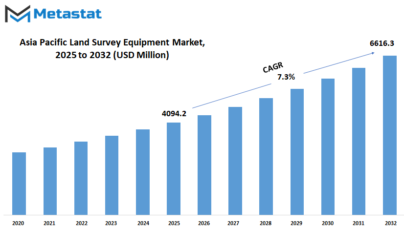
Asia Pacific land survey equipment market is estimated to reach $6616.3 Million by 2032; growing at a CAGR of 7.3% from 2025 to 2032.
GROWTH FACTORS
The Asia Pacific land survey equipment market is the fast-moving infrastructure projects ongoing in full swing throughout Asia. China, India, and other Southeast Asian countries heavily invest in quality infrastructure not just to spur economic growth but also to meet urbanization. The fast-rising pace of construction activity fuels the need for accurate surveying equipment, which must yield exact measurements and efficiently execute a project.
In addition, the urbanization factor in all of these countries, through infrastructure development, has also experienced high expansion and corresponding expansion in this market for land-survey equipment. These are all critical demand drivers for precise measurement tools utilized in construction works, mapping of land, and city planning.
The other key element is the issue of technological change in terms of land survey equipment. Emerging technological advancements in land survey equipment make the activities undertaken for surveying more efficient, simpler, and more precise. Such advances in technology enhance the productivity of land development and construction projects, by virtue of the fact that they not only provide for higher levels of accuracy in measurements obtained, but also minimize the actual time consumed for the surveying activity.
Nevertheless, to a degree, high initial expenses that are associated with cutting-edge surveys equipment and technical difficulties involved in incorporating new technologies within existing practice can be obstacles to market expansion. The cost of high-end advanced surveying equipment as an initial investment can act as a stumbling block to small companies and emerging economies.
It is likely to benefit from fresh opportunities arising in various industries. For example, expanded utilization of unmanned aerial vehicles, or drones, for aerial surveys is providing fresh opportunity to market players. A drone with high-resolution cameras and surveying software can effectively capture information over an extensive area; thus, it proves to be extremely useful for the use of land surveying.
In addition, with the growth in the importance given to smart city programs in nations around Asia-Pacific, the use of advanced land survey equipment will also expand. Smart cities are highly reliant on timely and precise geospatial information for urban planning exercises, infrastructure maintenance, and to conduct environmental monitoring, which in turn stimulates the land surveying technology market.
Trends like infrastructure expansion, innovation in technology, and smart cities will boost the growth of the Asia Pacific land survey equipment market. But issues related to costs and technological integration are the challenges to be overcome. The ongoing development of surveying technologies and the expanding usage of geospatial data will pave the way for the most viable prospects for the future growth of the market. Thus, the Asia Pacific land survey equipment market is the one that is following the path of significant growth with the existing trends and future outlook.
MARKET SEGMENTATION
By Product Type
In this regard, the Asia Pacific land survey equipment market is growing at an unprecedented rate. Various products driving this growth are GIS Asset Collection, GNSS, UAV, Theodolite, Total Station, Level Equipment, Laser Scanning, and Data Collectors. These technologies are an essential part of any land surveying business today and increase the precision of the work undertaken.
GIS asset collection systems take geographical information that serves as a foundation for mapping and planning. GNSS devices give precise location information, hence making the survey measurements as a whole more accurate. Aerial surveys are now being done with the help of UAVs, which offer high-resolution imagery and data capture.
Theodolites and Total Stations have been conventional but necessary instruments in the land surveying practice. They record angles and distances with a high level of precision, which is very critical in elaborate mapping and construction layout. Level devices are employed to maintain proper alignment and elevation measurement, which becomes extremely important in infrastructure development. Laser scanning technology rapidly captures complex 3D information on surfaces and structures, transforming as-built recordation and forensic analysis.
The efficient use of survey data ultimately simplifies analysis and decision-making carried out by the data collectors. These devices are critical to improving productivity and eliminating errors in survey activities.
In the future, Asia Pacific land survey equipment market will remain technology-driven. Improved sensors, enhanced data processing capacity, and interoperability with AI-based analytics further automate survey processes. These advancements will not only advance projects to completion quicker, enhancing accuracy in complicated terrain and urban environments.
By Application
It is within the new evolving terrain of Asia Pacific land survey equipment market that various applications are walking a path of growth: monitoring, inspection, point laying out, and volumetric calculation, among others. All of these are very significant in enhancing efficiency and accuracy within many other sectors.
The monitoring software makes sure that real-time data is obtained and processed to keep construction projects on schedule and within safety limits. Advanced survey equipment provides higher accuracy in monitoring structural health, ground displacement, and environmental effects for all concerned. This proactive action reduces risks and improves the management of projects overall.
Inspection software offers detailed evaluation of current buildings, roads, and infrastructure. Using survey equipment, engineers are able to conduct on-site evaluation to determine any potential weaknesses or where maintenance might be needed in a bid to extend the life of their infrastructure and ensure it remains reliable.
Use of layout points in planning aims at accurate positioning in space, which is crucial in building and developing infrastructure. Surveying equipment aids in the positioning of exact positions for a foundation, utilities, and building components lining them relative to architectural plans. The accuracy eliminates the frequency of defects during the construction process and enhances the quality of works as they relate to infrastructure.
Volumetric calculation software is used with surveying equipment, which gives precise measurements of landfills, excavation volumes, and stockpiles. This is extremely vital data if one must plan the distribution of resources, project cost estimation, or face regulatory needs. Accurate volumetric calculations effectively and efficiently conserve resources while providing environmental stewardship.
Other uses are specialized applications like terrain modeling, geophysical surveys, and cadastral mapping. These will then be used by various industries like mining, agriculture, urban planning, environmental management, and so on. The use of state-of-the-art survey technologies has the ability to make industries more productive, sustainable, and operationally excellent.
By End-User
The Asia Pacific land survey equipment market region is accelerating the growth path, led by a number of industries like construction, oil & gas, agriculture, mining, and others. Precision measurement and data are needed to plan and implement any project for these industries.
Construction activities are on the boom here, with infrastructure and urbanization on the rise. Land survey equipment thus comes into action here by ensuring that the right mapping of land parcels, building alignment, and optimal land use planning is attained. As the construction of cities expands and newer constructions arise, demand for advanced surveying equipment will continue to grow.
The Asia Pacific land survey equipment market plays an important role in catering to the oil & gas sector. In this industry, it is used in site preparation equipment, pipeline routing, and in environmental impact studies. Accurate survey information aids in maximizing the extraction of resources, reducing environmental impact, and compliance with regulatory requirements.
Another significant area is that of agriculture, wherein usage of surveying tools assists in land mapping, soil composition analysis, and crop management that is being grown. For these days, precision agricultural techniques are being adopted wherein large-scale surveys enable farmers to control irrigation, fertilizer inputs, and crop rotation for the purpose of introducing improvement in productivity and sustainability.
Survey devices are extensively used in mining operations for exploration, planning sites, and mining. Topographical information is valuable in establishing mineral deposits and open mine planning, providing safety in operating the mine. Thus, with abundant mineral resources that exist in Asia Pacific, opportunities related to advanced surveying equipment appear promising.
Other industries that would demand land survey gear, excluding the big ones, would include environmental monitoring, infrastructure maintenance, and disaster management, where precise measurements and spatial information play a critical role.
|
Forecast Period |
2025-2032 |
|
Market Size in 2025 |
$4094.2 million |
|
Market Size by 2032 |
$6616.3 Million |
|
Growth Rate from 2025 to 2032 |
7.3% |
|
Base Year |
2024 |
|
Regions Covered |
China, Japan, India, South Korea, Australia, South East Asia, Rest of Asia-Pacific |
REGIONAL ANALYSIS
The Asia Pacific land survey equipment market would be the most rapidly growing industry for land survey equipment in the coming years. The region consists of countries like India, China, Japan, South Korea, and others, which will slowly ramp up the demand for tools and technology adopted in land surveying.
The growth also would be boosted by growing infrastructure initiatives and urbanization in India. As urban areas keep on sprawling with increasing population figures and transport systems become increasingly modernized, the demand for more precise mapping and measurement technologies will increase. Another significant area for the market is China, where breakneck industrialization and suburban sprawl have joined together to place increasingly intense pressure on the country's infrastructure. The ambitious infrastructural initiatives of the country, like the Belt and Road Initiative, will need sophisticated land survey equipment to correctly plan and execute the developments. Its high-tech manufacturing and precision engineering sectors have their base in Japan, whose demand for cutting-edge surveying equipment will persist. South Korea, meanwhile, is a hub of technology innovation, and the country's investments in smart cities and other sustainable development initiatives will also fuel the market. In the rest of the Asia-Pacific, surveying tools of the modern variety will gradually gain traction as Vietnam, Indonesia, and Thailand concentrate on economic expansion and infrastructure improvement.
Much of the expansion in Asia Pacific land survey equipment market is due to various reasons: First, the high rate of industrialization and urbanization that enhances the magnitude of building construction activities and, accordingly, the demand for precise land survey information; this has pushed the demand for precise land measuring and mapping.
Secondly, regional governments are embarking on large-scale infrastructure projects as a way of urbanization and growth in the economic sector, where measurements of the land and mapping are needed. Since the progress has seen the advent of the global use of modern technology with the use of global positioning systems and laser scanning, surveying techniques are more convenient and effective. For this reason, a lot more individuals are currently proficient in using modern instruments. This thus provides a chance for the Asia Pacific to be a significant market for both manufacturers of land survey gear and the respective suppliers. It is the person who can innovate and speak fast to the needs of the domestic market who will have an upper hand. In the face of growing urban areas and the desire for developed infrastructure, there is only more space to call for dependable land survey equipment. Government agencies and private developers alike are amongst the stakeholders in the region who will increasingly look towards such tools to achieve and maintain the sustainability of their projects.
The outlook into the land survey equipment market in Asia-Pacific would appear to be quite favorable. This is indeed going to be quite uplifting with urbanization, building, infrastructure, and technology development calling for more accurate and effective surveying instruments. These trend adopters are going to be in a right place well to unlock the potential of opportunity generated by this vibrant and changing market.

COMPETITIVE PLAYERS
The Asia Pacific land survey equipment market is highly dynamic and competitive. There are various major players in the industry, each of which in turn contributes to its growth and innovation.
Guangdong Kolida Instrument Co., Ltd. provides the newest state-of-the-art technologies in survey instruments. Inherent accuracy and reliability identify products, meeting all requirements pertaining to land surveys. Regional leader Hexagon AB delivers seasoned know-how in the region, delivering a broad series of positioning technologies supported by software applications fitting into solutions.
The other major players include Hi-Target Surveying Instrument Co., Ltd., which is renowned for a broad array of products in the GNSS receivers and total stations segments. PENTAX Surveying is a strong player in optical instruments and a conglomerate with solutions for various environmental conditions.
Bosch Power Tools enables sophisticated measurement tools for improved productivity and precision in projects. Shanghai Huace Navigation Technology Ltd. supplies the GPS technology used for sophisticated positioning in all contemporary surveying work.
Other principal market contributors are South Surveying & Mapping Technology CO., LTD. and Suzhou FOIF Co., Ltd., dedicated to spearheading innovative survey equipment and geospatial solutions. Topcon Corporation and Trimble Inc. are world leaders as far as land survey practices and, separately, occupy the pinnacle of technological breakthrough and implementation.
To this regard, some of the outstanding firms are Stonex Srl, Ruide Surveying Instrument Co., Ltd., and Sanding (Shanghai) Surveying Instrument Co., Ltd., which have been discovered to focus on products to respond to particular surveying needs, like high-accuracy total stations, laser scanners, and digital levels. ADA Instruments and Hemisphere GNSS Inc. make specialized expertise in their fields, adding variety and richness to the market offering.
The Asia Pacific land survey equipment market is technically advanced and highly competitive with a multitude of players in the industry. Each of these players enumerated below has different capabilities and strengths to offer, thus the market continues to advance with the latest solutions for cutting-edge demands of surveying practices in today's complex times. The future for land survey equipment in the region is bright, with such firms collaborating and developing to address emerging challenges and opportunities in infrastructure development and other sectors.
Land Survey Equipment Market Key Segments:
By Product Type
- GIS Asset Collection
- GNSS
- UAV
- Theodolite
- Total Station
- Level Equipment
- Laser Scanning
- Data Collectors
By Application
- Monitoring
- Inspection
- Layout Points
- Volumetric Calculation
- Others
By End-User
- Construction
- Oil & Gas
- Agriculture
- Mining
- Others
Key Asia Pacific Land Survey Equipment Industry Players
- Guangdong Kolida Instrument Co., Ltd.
- Hexagon AB
- Hi-Target Surveying Instrument Co., Ltd.
- PENTAX Surveying
- Bosch Power Tools
- Shanghai Huace Navigation Technology Ltd.
- South Surveying & Mapping Technology CO., LTD.
- Suzhou FOIF Co., Ltd.
- Topcon Corporation
- Trimble Inc.
- Stonex Srl
- Ruide Surveying Instrument Co., Ltd.
- Sanding (Shanghai) Surveying Instrument Co., Ltd.
- ADA Instruments
- Hemisphere GNSS Inc.
WHAT REPORT PROVIDES
- Full in-depth analysis of the parent Industry
- Important changes in market and its dynamics
- Segmentation details of the market
- Former, on-going, and projected market analysis in terms of volume and value
- Assessment of niche industry developments
- Market share analysis
- Key strategies of major players
- Emerging segments and regional growth potential


 US: +1 3023308252


