Global Land Surveying Market - Comprehensive Data-Driven Market Analysis & Strategic Outlook
The global land surveying market and industry will transcend the conventional notion of boundary marking or terrain mapping. In the future, this market will emerge as a platform for sophisticated development projects, linking infrastructure, technology, and sustainable practices in ways that were previously distant hopes. What was once a physical-measurement-based service will be converted into a data-fueled strategy that will guide wiser decision-making for governments, companies, and communities. The sector will move beyond the tangible necessity of documenting land data and will become a prime driver of urban planning, renewable energy infusion, and resilience in a changing climate.
What opportunities may want to unfold for the global land surveying market as clever towns and virtual mapping transform how we measure and control land? How might technological disruptions like AI, drones, and cloud-based structures reshape traditional surveying practices at the same time as raising new uncertainties? Could the enterprise conquer value and skill barriers to release its complete capability in shaping destiny infrastructure and improvement?
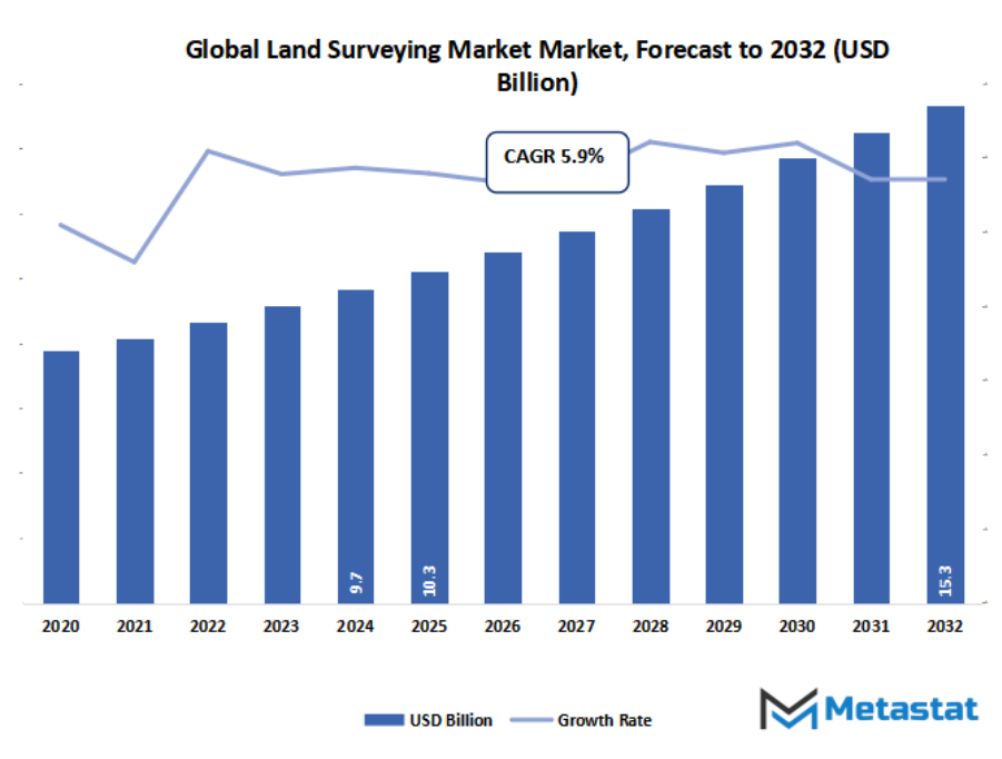
- Global land surveying market valued at approximately USD 10.3 Billion in 2025, growing at a CAGR of around 5.9% through 2032, with potential to exceed USD 15.3 Billion.
- Hardware account for nearly 46.0% market revenues, driving innovation and expanding applications through intense research.
- Key trends driving growth: Increased infrastructure development and construction projects globally., Adoption of advanced technologies like LiDAR and drones for precision.
- Opportunities include Growing demand for 3D mapping and modeling in urban planning.
- Key insight: The market is set to grow exponentially in value over the next decade, highlighting significant growth opportunities.
The global land surveying market will no longer remain limited to geography measurement alone but will enter fields like environmental monitoring, disaster management planning, and space applications. As digital tools become sharper, survey data will no longer remain stored for construction activities only but will actively define how cities, rural, and even coastal areas will be governed in the future. This paradigm change will see the industry extend its influence well beyond construction and real estate. It will aid agriculture by forecasting land use trends, help preserve ecosystems by charting sensitive regions, and ready areas for natural disasters with precise risk modeling.
Market Segmentation Analysis
The global land surveying market is mainly classified based on Component, Application, End-use, .
By Component is further segmented into:
- Hardware - The hardware aspect of the global land surveying market will keep growing with sophisticated sensors, drones, and GPS-enabled equipment. Precision instruments that are capable of withstanding difficult terrains will be the focus of future development. This will minimize manual labour, accelerate survey operations, and enable real-time measurement with accuracy.
- Services - The market will move towards bundled solutions. Future solutions will focus on remote access, cloud-based reporting, and ongoing support. Tailor-made service packages will enable end-users to conduct projects smoothly. Professional expertise will be in greater demand as technology continues to grow more complex but common place.
- Software - Software will define the future of the global land surveying market by making complicated data management easier. Advanced analytics, automated mapping, and AI-modeling will revolutionize project execution. Software platforms will facilitate real-time collaboration, making team communication simpler. This will improve decision-making speed and dependable project results all over the world.
By Application the market is divided into:
- Inspection - Inspection solutions in the global land surveying market will be directed towards preventive measures. Sophisticated inspection systems will enable early identification of land shifts, construction faults, or boundary disputes. These advancements will minimize delays and conflicts and increase long-term safety and cost effectiveness in infrastructure and commercial development globally.
- Monitoring - Monitoring applications within the market will increase steadily with increasing satellite and drone technology. Next-generation monitoring systems will follow environmental changes, structural transformations, and urban growth. Real-time insights will enhance planning and sustainability. This will render monitoring essential for those projects that need ongoing monitoring and adaptability.
- Volumetric Calculations -Volume calculations in the market will also be automated. High-resolution imaging and 3D mapping will determine landfills, mines, and building materials volumes with unparalleled precision. Automated volumetric analysis will reduce time, cut down on mistakes, and prevent waste in planning and assigning resources across large-scale operations globally.
- Layout Points - Layout point applications within the global land surveying market will increase construction alignment accuracy. Automated layout systems will become interconnected with robotics to provide accurate positioning of buildings. The future will witness layout operations being performed quicker with fewer mistakes. This advancement will straight away enhance the quality of construction and minimize project delays.
- Others - The other uses of the global land surveying market will grow towards smart city planning, optimization of agriculture, and disaster management. Solutions based on data will produce safer, more efficient cities. Surveying will be instrumental in designing future landscapes, enabling sustainability, and enhancing resilience in infrastructure under varying global conditions.
By End-use the market is further divided into:
- Commercial - Commercial applications in the global land surveying market will grow with infrastructure development, real estate expansion, and urban planning. Companies will use digital surveying methods for speed and accuracy. Future demand will revolve around green projects, where accurate land information will minimize risks and increase efficiency in large-scale development.
- Defense - Defense uses of the market will emphasize strategic mapping and safe boundary evaluations. State-of-the-art military-grade equipment will aid in surveillance, terrain mapping, and infrastructure formation. The future will see more convergence of drones, satellites, and AI to enhance defense strength with assurance of national security through proper land evaluation.
- Service Providers - Service providers within the global land surveying market will primarily manage technology and expertise for end customers. As there is increasing complexity in hardware and software, the trend will shift towards more outsourcing. Providers will emphasize providing stable, low-cost, and flexible solutions for construction, defense, and business projects across the globe.
|
Forecast Period
|
2025-2032
|
|
Market Size in 2025
|
$10.3 Billion
|
|
Market Size by 2032
|
$15.3 Billion
|
|
Growth Rate from 2025 to 2032
|
5.9%
|
|
Base Year
|
2024
|
|
Regions Covered
|
North America, Europe, Asia-Pacific, South America, Middle East & Africa
|
Geographic Dynamics
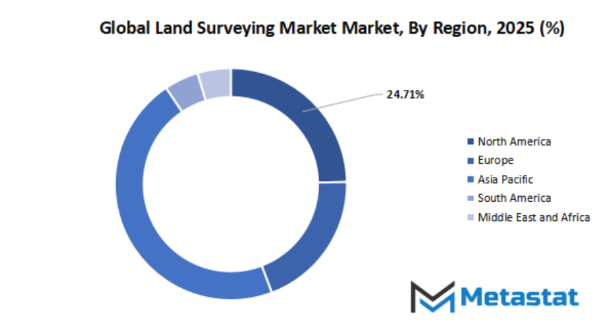
Based on geography, global land surveying market is divided into North America, Europe, Asia-Pacific, South America, and Middle East & Africa. North America is further divided in the U.S., Canada, and Mexico, whereas Europe consists of the UK, Germany, France, Italy, and Rest of Europe. Asia-Pacific is segmented into India, China, Japan, South Korea, and Rest of Asia-Pacific. The South America region includes Brazil, Argentina, and the Rest of South America, while the Middle East & Africa is categorized into GCC Countries, Egypt, South Africa, and Rest of Middle East & Africa.
Competitive Landscape & Strategic Insights
The global land surveying market has evolved into a very competitive business that will keep growing as technology influences how measuring, mapping, and collecting spatial data are done. Land surveying is no longer simply a matter of conventional ways of establishing boundaries; it is now the cornerstone of infrastructure development, building, property, mining, and city planning. With governments and private developers all over the world placing investment in projects needing precise geographic information, demand for competent and innovative surveying tools will continue to be high. This increased demand has seen both experienced international players and ambitious regional participants combine to offer their own innovations to the market.
The sector is dominated by the presence of leading firms that have already established an international reputation for precision and dependability. Trimble Inc., Hexagon AB, Topcon Corporation, and Leica Geosystems under Hexagon are some of the best-known names. These firms have established benchmarks in precision instruments, GPS solutions, and digital mapping technologies. Their solutions are globally recognized for their high degree of accuracy in measuring and positioning. Accompanied by them, Carl Zeiss AG, Nikon-Trimble Co., Ltd., and Spectra Precision, a Trimble company, fill out the sector with their knowledge of optics, imagery, and surveying technologies so that customers can obtain sophisticated instruments for sophisticated projects.
Meanwhile, local competitors continue to make their presence felt. Firms such as South Surveying & Mapping Instrument Co., Ltd. and Shanghai Huace Navigation Technology Ltd. are bringing in affordable but effective options, particularly in fast-expanding markets in Asia. Their existence means that the sector will not be dominated by international behemoths alone but will see opportunities for new players who are efficient enough to respond quickly to local needs. These companies usually introduce competitive pricing and innovative strategies that attract local governments and businesses to adopt efficient solutions.
Technology companies also have a key role in driving the market direction. Faro Technologies as a specialist in 3D measurement and imaging systems and Hemisphere GNSS and JAVAD GNSS as leaders in satellite navigation are expanding the potential of what land surveying can deliver. With GNSS, laser scanning and improvement in digital mapping, such firms are early, more accurate and data-operated. They guarantee that the market will still not stand up, but will continue to develop to meet the growing needs for smart cities, permanent infrastructure and world connectivity.
Overall, the global land surveying market is characterized by the co-existence of global leaders established in the market and the above regional players, both contribute to the advancement of the industries. Established players such as Trimbal, Hexagon and Topcon will still be in charge with their established techniques, while players from Asia and other continents will vie for increased acknowledgment by providing affordable and optimal solutions. With the increasing requirement of accurate mapping and measurement in all industries, rivalry between these businesses will fuel innovation and see that the future of the land survey is dynamic and important for development globally.
Market Risks & Opportunities
Restraints & Challenges:
High cost of advanced surveying equipment and software. - The global land surveying market will be increasingly under financial pressure as technology continues to advance. Hardware and software to make measurements highly accurate are expensive, making it hard for smaller companies to adapt. Future development will rely on cost reduction and developing solutions that equate accuracy with affordability for broader availability.
Regulatory complexities and requirement for licensed professionals. - The global land surveying market will remain subject to regulatory issues with governments imposing tough regulations. Accuracy and credibility are assured by the requirement for licenses but at the cost of slowing down the process of project delivery. Future growth will depend on simplified regulations and international acceptance of certifications to facilitate quicker project delivery.
Opportunities:
Growing demand for 3D mapping and modeling in urban planning. - The global land surveying market will acquire robust momentum with the increasing adoption of 3D mapping and modeling. Future cities will be based on precise digital plans to deal with rapid urbanization. Incorporation of cutting-edge mapping in smart city initiatives will provide avenues for quicker, safer, and greener infrastructure planning.
Forecast & Future Outlook
- Short-Term (1–2 Years): Recovery from COVID-19 disruptions with renewed testing demand as healthcare providers emphasize metabolic risk monitoring.
- Mid-Term (3–5 Years): Greater automation and multiplex assay adoption improve throughput and cost efficiency, increasing clinical adoption.
- Long-Term (6–10 Years): Potential integration into routine metabolic screening programs globally, supported by replacement of conventional tests with advanced biomarker panels.
Market size is forecast to rise from USD 10.3 Billion in 2025 to over USD 15.3 Billion by 2032. Land Surveying will maintain dominance but face growing competition from emerging formats.
Looking beyond current scope, the global land surveying market will be required to create new standards of accuracy and access. With its influence going out to satellite-based mapping, artificial intelligence integration, and real-time data sharing, the sector will ultimately become a cross-sector collaborator. Instead of being perceived as a supporting activity, it will become a strategic tool that will shape the efficiency, sustainability, and resilience of future societies.
Report Coverage
This research report categorizes the market based on various segments and regions, forecasts revenue growth, and analyzes trends in each submarket. The report analyses the key growth drivers, opportunities, and challenges influencing the market. Recent market developments and competitive strategies such as expansion, type launch, development, partnership, merger, and acquisition have been included to draw the competitive landscape in the market. The report strategically identifies and profiles the key market players and analyses their core competencies in each sub-segment of the global land surveying market.
By Component:
- Hardware
- Services
- Software
By Application:
- Inspection
- Monitoring
- Volumetric Calculations
- Layout Points
- Others
By End-use:
- Commercial
- Defense
- Service Providers
Key Global Land Surveying Industry Players:
- Trimble Inc.
- Hexagon AB
- Topcon Corporation
- Leica Geosystems (part of Hexagon)
- South Surveying & Mapping Instrument Co. Ltd.
- Shanghai Huace Navigation Technology Ltd.
- Faro Technologies
- GeoMax AG
- Carl Zeiss AG
- Sokkia Corporation
- Nikon-Trimble Co. Ltd.
- Spectra Precision (a Trimble brand)
- CHC Navigation
- Hemisphere GNSS
- JAVAD GNSS
WHAT REPORT PROVIDES
- Full in-depth analysis of the parent Industry
- Important changes in market and its dynamics
- Segmentation details of the market
- Former, on-going, and projected market analysis in terms of volume and value
- Assessment of niche industry developments
- Market share analysis
- Key strategies of major players
- Emerging segments and regional growth potential