

MARKET OVERVIEW
The equipment for land surveying across the Asia Pacific has grown to represent a key segment in a wider field: geospatial technology. This includes tools and devices that measure and map land. The market comes with exact instruments developed to work in construction and engineering, through environmental studies to urban planning. Of late, the industry has been experiencing manifold growth; technology contributes greatly to changing conventional surveying methods.
The core of the land survey equipment market in Asia Pacific is a range of sophisticated devices: Total Stations, Theodolites, GNSS Systems, Laser Scanners, and Drones. Total stations combine electronic distance measurement and angle measurement for delivering accurate data to achieve effective site analysis and layout. Theodolites, conventionally used for the same purpose, are giving place to digital versions for better accuracy and ease of use. The GNSS systems provide strong solutions to geolocation and mapping in large projects that are impossible without exact positioning. Fast data collection speed and high-resolution image acquisition gained popularity for laser scanners in the Asia Pacific region. These devices permit creating detailed 3D models of areas under survey, which essentially adds value to the visualization and planning phases of several projects.
The other technological marvel is that of the drones, which have changed the face of land surveying with their unique aerial perspective that was hitherto difficult to capture. Equipped with high-definition cameras and advanced sensors, the drones can cover large areas quickly, hence saving much of the time and labor characteristic of land surveying. The same can be witnessed in the Asia Pacific Land Survey Equipment market, which will continuously undergo transformation with evolving technology. Developments related to artificial intelligence and machine learning are likely to further enhance this capability of surveying equipment.
For instance, AI algorithms can analyze large amounts of data collected by such devices to give deeper insights and accurate predictions. Machine learning can increase the speed of processing data and reduce errors, hence increasing the reliability of the survey result. With advancing urbanization and infrastructural development, demand for advanced surveying equipment within the Asia Pacific region will be strong. Extensive infrastructure development works are in order within countries like China, India, and Japan, which would definitely require accurate land survey tools.
These investments could be attributed to meeting the demands of the growing population and subsequent expansion of urban areas. The accuracy provided by modern surveying equipment will be relied on substantially for the construction of smart cities, highways, and transportation networks. Advancements in the Asia Pacific Land Survey Equipment market will benefit not only the built environment but are also bound to go a long way in environmental monitoring and conservation. Land surveillance is indispensable for tracing changes in landscapes and assessing their impacts on climate change; these are necessary considerations in initiating sustainable development projects.
High-precision instruments will be very instrumental in careful planning to balance development with environmental stewardship. Furthermore, it will find a home in cloud computing and the IoT within surveying equipment, where it can have a better real-time data sharing and analysis. It will enable surveyors to have the position where they can remotely access and analyze data for more flexibility and responsiveness of their operation. In this way, it enables high levels of connectivity, driving more collaborative and informed decision-making processes—critical to large-scale projects that span multiple stakeholders.
The Asia Pacific Land Survey Equipment market is one that is leading in technological innovation to ensure precision and efficiency in land measurement and mapping. On the back of AI, drone technology, and IoT innovations, continuous evolution in this industry is tailored to meet the increasing demands of urbanization, infrastructural development, and environmental conservation. The trajectory of the market points toward a future wherein land surveying is increasingly integrated into the development and sustainability efforts for the region.
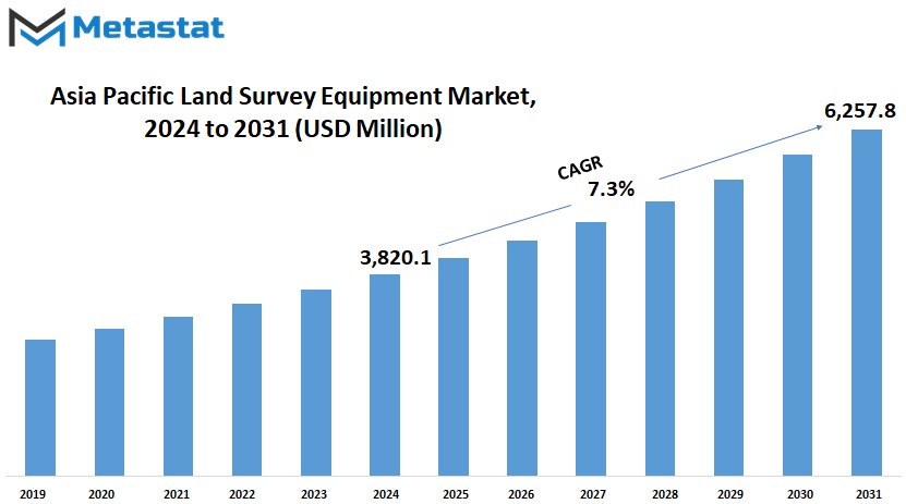
Asia Pacific Land Survey Equipment market is estimated to reach $6257.8 Million by 2031; growing at a CAGR of 7.3% from 2024 to 2031.
GROWTH FACTORS
Further on, the factor of urbanization in most of the countries, with infrastructure development, has also seen significant growth and proportionate growth in the market for land-survey equipment in this region. These are major factors driving demand for accurate measurement tools used in construction projects, land mapping, and urban planning.
Key growth factors of the market include the rapid infrastructure projects that are going on in full swing across Asia Pacific. Countries like China, India, and other Southeast Asian nations invest heavily in high-quality infrastructure not only to support their economic growth but also to accommodate urbanization. The rapid surge in construction activity drives the demand for precise surveying equipment, which should bring out exact measurements and effectively carry out a project.
Another critical factor is technological change regarding equipment used for land surveys. New technological innovations in land survey equipment make the processes involved in surveying easier, more efficient, and more accurate. Such technological changes augment the productivity of construction and land development projects, through the fact that they not only offer greater precision in measurements taken, but also reduce the actual time required for the activity of surveying.
However, to some extent, high initial costs that relate to advanced surveying equipment and the complexity of integrating new technologies into existing workflows may challenge market growth. The initial investment needed for high-end sophisticated surveying tools can serve as a barrier to smaller firms and developing economies.
It is expected to gain from new opportunities opening up in different sectors. For instance, increasing use of unmanned aerial vehicles, also known as drones, for aerial surveys is creating new opportunity for players in the market. A drone fitted with high-resolution cameras and surveying software is capable of capturing information effectively over a large area; hence, it becomes very useful for the application of land surveying.
Further, with the increase in the emphasis placed on smart city initiatives in countries across Asia-Pacific, the demand for advanced land survey equipment will also increase. Smart cities are much dependent on up-to-date and accurate geospatial data for urban planning processes, infrastructure management, and to carry out environmental monitoring, which further drives the market for land surveying technologies.
Factors such as infrastructure development, technological advancement, and smart city initiatives will drive the growth of the land survey equipment market in the Asia Pacific. However, challenges associated with costs and integration of technology are the issues to be addressed. The continuous development of surveying technologies and the increasing application of geospatial data will give way to the most viable opportunities for the market's future expansion. Accordingly, the Asia Pacific land survey equipment market is the one that is on the path of considerable growth with the ongoing trends and future prospects.
MARKET SEGMENTATION
By Product Type
In this respect, the land survey equipment market is developing at a tremendous pace in the Asia Pacific region. Different products pushing this growth include GIS Asset Collection, GNSS, UAV, Theodolite, Total Station, Level Equipment, Laser Scanning, and Data Collectors. All these technologies form an integral part of any land surveying practice these days and enhance the accuracy of the work involved.
GIS asset collection systems capture geographical data that becomes a basis for mapping and planning. GNSS devices provide location information of high accuracy, thereby increasing the accuracy of the survey measurements in general. Aerial surveys are increasingly being carried out with the use of UAVs, which deliver high-resolution imagery and data capture.
Theodolites and Total Stations have been traditional but essential tools in the land surveying profession. They measure angles and distances with a high degree of accuracy, which is very important in detailed mapping and construction layout. Level equipment is used to ensure proper alignment and elevation measure, which becomes very critical in infrastructure projects. Laser scanning technology quickly captures intricate 3D data about surfaces and structures, revolutionizing as-built documentation and forensic analysis.
The effective integration of survey data, in the end, eases analysis and decision-making processed by the data collectors. These tools are pivotal in enhancing productivity and reducing errors in survey operations.
In the future, land survey equipment will still be driven by technology. Better sensors, improved data processing capability, and integration with AI-driven analytics further automate survey workflows. These developments will not only help projects to their completion faster, improving accuracy in complex terrain and urban settings.

By Application
It is in the current changing landscape of land survey equipment in the Asia Pacific that different applications are treading a growth path: monitoring, inspection, laying out points, and volumetric calculation, among others. All these are quite important in improving efficiency and precision within various other industries.
The monitoring applications ensure that real-time data is captured and analyzed to keep construction projects on track and within safety parameters. State-of-the-art survey equipment gives greater accuracy in monitoring structural integrity, ground movement, and environmental impacts for all stakeholders. This proactive approach minimizes risks and enhances the management of projects in general.
Inspection applications provide detailed assessment of existing structures, roads, and infrastructure. With the help of survey equipment, engineers can undertake on-site assessment to identify any possible weaknesses or areas where maintenance could be required in order to lengthen the life span of their infrastructure and maintain its reliability without chances of frequent failures.
Application of layout points in planning targets precise spatial positioning, which is very essential in constructing and developing structures. Survey equipment helps mark out the exact locations for a foundation, utilities, components of a building lining them in relation to the architectural plans. This accuracy reduces the occurrence of flaws during construction and increases the quality of works related to infrastructure.
Volumetric calculation applications are applied with survey equipment, which accurately measures stockpiles, excavation volumes, and landfills. This is very critical information when one needs to plan the allocation of resources, estimate the cost of a project, or adhere to regulatory requirements. Precise volumetric calculations efficiently and effectively manage resources while ensuring environmental stewardship.
Other applications include specialized uses such as terrain modeling, geophysical surveys, and cadastral mapping. These will then serve diverse industries like mining, agriculture, urban planning, environmental management, and so on. The adoption of advanced survey technologies can help industries become more productive, sustainable, and operationally excellent.
By End-User
The land survey equipment market in the Asia Pacific region is fast-tracking on the growth curve, driven by several industries such as construction, oil & gas, agriculture, mining, and others. Accurate measurements and data are essential for planning and executing any project for these sectors.
Construction works are at their boom in this region, with urbanization and infrastructure at their peak. Land survey equipment therefore comes into play here by making sure that the correct mapping of land parcels, structure alignment, and efficient land use planning is achieved. As cities grow and newer developments come up, demand for state-of-the-art surveying tools will keep increasing.
Land survey equipment goes a long way in serving the oil & gas industry. In this sector, it is deployed in equipment for site preparation, routing of pipelines, and in environmental impact assessments. Precise survey data helps in optimizing resource extraction, minimizing environmental footprint, and adhering to regulatory standards.
Another important sector is agriculture, where application of surveying equipment helps in mapping lands, analyzing the composition of soil, and managing the crops cultivated. For these days, precision agriculture methods are being followed wherein extensive surveys allow farmers to manage irrigation, fertilizer application, and crop rotation for bringing improvement in productivity and sustainability.
Survey equipment is vastly utilized in mining operations for the purpose of exploration, site planning, and extraction. Topographical data is useful in determining mineral deposits and designing open mines, ensuring safety while running the mine. Therefore, with the rich mineral resources available in Asia Pacific, prospects associated with sophisticated surveying instruments seem bright.
Other sectors contributing to the demand for land survey equipment, apart from the major ones, would be environmental monitoring, maintenance of infrastructure, and disaster management—where exact measurements and spatial data are crucial.
REGIONAL ANALYSIS
Asia-Pacific would be the fastest-growing region in the land survey equipment market over the next few years. The region includes countries such as India, China, Japan, South Korea, and others, which will gradually increase their demand for the tools and technologies used in land surveying.
The growth also will be fueled by increasing infrastructure projects and urbanization in India. As cities continue to expand with growing population sizes and transportation systems undergo further modernization, the need for more accurate mapping and measurement tools will grow. Another important region for the market is China, where breakneck industrialization and urban sprawl have combined to put ever-greater pressure on the country's infrastructure. The country's ambitious infrastructure projects, such as the Belt and Road Initiative, will require advanced land survey equipment to ensure accurate planning and execution.
High-tech manufacturing and precision engineering industries are based in Japan, which will continue to demand state-of-the-art surveying instruments. On the other hand, South Korea is a hotbed of technological innovation, and its investments in smart cities and other sustainable development projects will contribute to the market. In the rest of Asia-Pacific, modern surveying tools will see incremental adoption as countries such as Vietnam, Indonesia, and Thailand focus on economic growth and infrastructure betterment.
A large part of the growth in the land survey equipment market in Asia-Pacific is attributed to several factors: First, the fast pace of urbanization and industrialization that increases the scale of building construction works and, by extension, the demand for accurate land survey data; this has increased the demand for accurate land measuring and mapping. Secondly, governments in the region are undertaking ambitious infrastructure projects as a means of promoting economic growth, wherein accurate land measurements and mapping are required. Because the advancement has led to the introduction of the use of modern technology by employing global positioning systems and laser scanning, surveying methods are now more comfortable and efficient. That is why many more people are now adept at using modern equipment. This therefore is an opportunity for the Asia Pacific region to become an important market for the manufacturers of land survey equipment and the suppliers of the respective manufacturers.
In the wake of increasing urban populations and the need for developed infrastructure, there is only more room to demand reliable land survey equipment. From government agencies to private developers, stakeholders across the region will continue to turn to such tools for accomplishing and maintaining the sustainability of their projects. The perspective into the land survey equipment market in Asia-Pacific would seem to be pretty favorable. This will certainly be very enhancing with the increase in urbanization, construction, infrastructure, and technological advancement requiring more precise and efficient surveying equipment. The stakeholders who adopt these trends are going to position themselves in a good position well to realize the potential of opportunities arising from this dynamic and evolving market.
COMPETITIVE PLAYERS
The land survey equipment market is very dynamic and competitive in the Asia Pacific region. There exist several principal actors within the industry, each of which individually makes a contribution to its development and innovation.
Guangdong Kolida Instrument Co., Ltd. supplies the latest state-of-the-art technologies in survey instruments. Inherent precision and reliability distinguish products, serving all needs related to land surveys. Global leader Hexagon AB brings solid expertise in the region, providing a wide range of positioning technologies coupled with software applications integrating into solutions.
The other key participants are Hi-Target Surveying Instrument Co., Ltd., known for a wide product offering in the segments of GNSS receivers and total stations. PENTAX Surveying has proved to be a robust player in optical instruments and is part of a conglomerate with solutions for different environmental conditions.
Bosch Power Tools supports advanced measurement tools to enhance productivity and accuracy in sites. Shanghai Huace Navigation Technology Ltd. provides the GPS technology required for advanced positioning in all modern surveying tasks.
Other key market players include South Surveying & Mapping Technology CO., LTD. and Suzhou FOIF Co., Ltd., committed to pioneering innovative survey instruments and geospatial solutions. Topcon Corporation and Trimble Inc. are global leaders regarding land surveying practices and, individually, sit at the forefront of technological advancement and integration.
To this respect, some remarkable companies include Stonex Srl, Ruide Surveying Instrument Co., Ltd., and Sanding (Shanghai) Surveying Instrument Co., Ltd., which have been found to concentrate on products to answer specific surveying applications, such as high-precision total stations, laser scanners, and digital levels. ADA Instruments and Hemisphere GNSS Inc. contribute specialized competencies in their respective areas, enhancing the variety and depth of what the market has to offer.
The land survey equipment market in the Asia Pacific region is highly competitive and technically innovative, driven by a myriad of industry players. Each of these companies—which are enumerated further below brings different strengths and capabilities into the fray, thereby ensuring the continuation of the market evolving with cutting-edge solutions that meet the increasingly complex demands of surveying practices today. The outlook for land survey equipment is promising in the region, as such companies are partnering and innovating to meet emergent challenges and opportunities in infrastructure development and other areas.
Asia Pacific Land Survey Equipment Market Key Segments:
By Product Type
- GIS Asset Collection
- GNSS
- UAV
- Theodolite
- Total Station
- Level Equipment
- Laser Scanning
- Data Collectors
By Application
- Monitoring
- Inspection
- Layout Points
- Volumetric Calculation
- Others
By End-User
- Construction
- Oil & Gas
- Agriculture
- Mining
- Others
Key Asia Pacific Land Survey Equipment Industry Players
- Guangdong Kolida Instrument Co., Ltd.
- Hexagon AB
- Hi-Target Surveying Instrument Co., Ltd.
- PENTAX Surveying
- Bosch Power Tools
- Shanghai Huace Navigation Technology Ltd.
- South Surveying & Mapping Technology CO., LTD.
- Suzhou FOIF Co., Ltd.
- Topcon Corporation
- Trimble Inc.
- Stonex Srl
- Ruide Surveying Instrument Co., Ltd.
- Sanding (Shanghai) Surveying Instrument Co., Ltd.
- ADA Instruments
- Hemisphere GNSS Inc.
WHAT REPORT PROVIDES
- Full in-depth analysis of the parent Industry
- Important changes in market and its dynamics
- Segmentation details of the market
- Former, on-going, and projected market analysis in terms of volume and value
- Assessment of niche industry developments
- Market share analysis
- Key strategies of major players
- Emerging segments and regional growth potential


 US: +1 3023308252


